Recent heavy rains across the province have swollen lakes and rivers across several watersheds and resulted in water ponding on many properties. Some properties have been affected by flooding.
Flood water and water ponding around wells and septic systems can affect the safety of your drinking water and how your septic system works. The Leeds Grenville and Lanark Health Unit is advising those whose wells are directly affected by these conditions to boil their water for one minute at a rolling boil before drinking the water. Have your well water tested for bacteria.
If your septic system has been affected, limit water usage by taking quick showers rather than baths, avoid using the dishwasher, garbage disposal and washing machine and flush your toilets only when necessary. Ensure your basement sump pump is not going into the septic system.
Do not pump out your septic tank when the soil around the tank or the leaching bed is still saturated with water. High ground water levels may cause an empty septic tank to float and break out of the ground, and damage the tank and connecting plumbing.
The following tips will help protect your family during flooding events:
- Keep your family safe by keeping family members and pets away from and out of the flood water.
- DO NOT enter areas where electrical systems have been affected by flood water as you may be electrocuted. Always wait for clearance from the electrical authority before entering these areas.
- Building materials, clothing and furniture exposed to flood waters are likely contaminated with sewage and can support the growth of mold. Some items can be cleaned and disinfected; others may need to be thrown out.
- Ask for professional advice during clean up. If you try to save and clean items on your own, wear protective clothing, a mask and gloves.
Spring Flooding
Thawing of snow and ice combined with spring rains may cause localized flooding on some properties. Flood water and water ponding around wells can affect the safety of your drinking water. The Leeds, Grenville and Lanark Health Unit is advising those whose wells are directly affected by these conditions to boil their water for one minute at a rolling boil before drinking the water, or use an alternate safe source until you test your water and confirm that it is safe to drink.
A few tips to keep in mind if your property is prone to flooding:
- Monitor weather and take warnings seriously.
- Monitor your local conservation authority website and alerts for localized flooding risks.
- Ensure drainage ditches, etc. around your home are clear and can function during periods of heavy rain.
- Label the shut off valves and the direction to turn off the gas, water, power, etc. If you must leave your home due to rising flood waters, turn off the power, gas, etc.
- Maintain your home to keep water out.
- Move items likely to be affected by a flood water to higher areas where possible.
- Ensure chemicals, cleaners; gas cans, etc. are stored in such a manner as not to contaminate flood water.
- Ensure you have a supply of fuel for generators and pumps in the event of power outage. Store fuel in a manner so as not to contaminate flood water.
- Have an emergency kit stocked; be sure to include important documents, cash, safe drinking water, food and medication.
Visit the Well Water Sampling for drinking water information including: where you can pick up and drop off your free water bottle samples; how to take a sample; how to disinfect your well (if required). For more information, call the Leeds, Grenville & Lanark District Health Unit at 1-800-660-5853.
After Flooding
After flooding, well owners should take actions to:
- make their water supplies safe for consumption; and
- protect the groundwater resource used as a source of drinking water.
When a water supply well has been affected by flood waters, the water within a well may be contaminated with waterborne pathogens (germs) that can cause serious illness in humans and pets. The water in the well can also be contaminated by debris, fuel oil or other chemical products released during the flood.
During flooding, the ground around the well may also erode, possibly creating unsafe conditions or a pathway for surface water and contaminants to enter the well. In other cases, the electrical wires attached to the pump in a well may be damaged risking
electrocution. Therefore, well owners should exercise extreme caution approaching their wells, especially older, large diameter dug wells after a flood.
If a well owner believes that the well has been contaminated by flood water, the well owner should discontinue using the water in the well for drinking and cooking purposes and use potable water from another source.
Under the Wells Regulation [R.R.O. 1990, Regulation 903 (Wells) as amended made under the Ontario Water Resources Act, R.S.O. 1990, c. O. 40]:
- the well owner must maintain the well to prevent the entry of surface water and other foreign materials.
- if laboratory analysis of water samples from the well show the well is producing water that is not potable, then the well owner must contact the local Medical Officer of Health (MOH) and follow his or her advice or immediately abandon the well. As an alternative to contacting the MOH, the well owner could contact the Director appointed under the Wells Regulation at 1-888-396-9355 (WELL) for written consent not to abandon the well.
To bring a well back into service safely, a well owner should consider contacting:
- a qualified registered professional (e.g. professional engineer or professional geoscientist) or a licensed well driller to evaluate and service a drilled well;
- a qualified registered professional or a licensed well digger to evaluate and service a dug well;
- a licensed pump installer and, if necessary a certified electrician, to evaluate and service the well pump.
Note - A residential private well owner can work on and disinfect his or her own well. However, there are some safety considerations when working on a well and many technical steps needed to properly clean and disinfect a well. Therefore, the well owner should consider retaining the services of a qualified professional or qualified technician as noted above.
If the well structure, pump and surrounding ground surface have been repaired or are deemed sound, the water in the well should be pumped and disinfected by a licensed well technician as outlined in Chapter 8: Well Disinfection of the Water Supply Wells – Requirements and Best Management Practices manual published by the Ministry of the Environment and Climate Change, revised 2015.
The Well Disinfection chapter of the manual provides the following steps to properly disinfect a well:
- Initial steps which include:
- following sanitary practices
- removing any debris from a well
- Thorough flushing of the well
- Treatment with a properly prepared chlorine solution, i.e. “shock” chlorination
- Discharge of heavily chlorinated water from the well and the plumbing
- Collection and analysis of water samples for indicator bacterial parameters
The Well Disinfection chapter of the manual is available here.
A synopsis of the Well Disinfection chapter for interested well owners is provided in the Wells Regulation – Well Disinfection 2011 technical bulletin and is available the government of Ontario's website.
Information on proper well maintenance, and other well related topics, is available on the Ontario.ca website.
What steps should I take if my septic system is flooded?
- It is strongly recommended that the system should not be used while the septic drain field or tanks are covered with water. The sewage system should not be used until the water in the septic drain field is below the distribution pipes.
- If the system must be used, conserve water as much as possible while the system attempts to restore itself as the ground water table falls.
- Flood water may be contaminated with sewage. Protect yourself by wearing protective equipment such as gloves, protective eyewear, a face mask and rubber boots. Be sure to wash your hands frequently with soap and water.
- Do not pump your septic tank. Pumping out a septic tank that is sitting in saturated soil may cause it to “pop out” of the ground. Newer systems are more likely to pop out than older systems because the soil may not have completely settled and compacted around the septic tank.
- Try to avoid using any heavy machinery near the septic drain field or tanks in a saturated state, as they are especially vulnerable to damage under flooded conditions.
- If sewage has backed up into a basement, clean the area and disinfect the floor. Use a chlorine solution of a half cup of chlorine bleach to a gallon of water when mopping the floor.
- If you have a ground water well, do not drink the water until water testing proves it to be safe for consumption.
For more information, please contact Eric Kohlsmith, Septic Inspector, Mississippi Rideau Septic System Office at 613 253 0006 ext. 256 or by email at This email address is being protected from spambots. You need JavaScript enabled to view it.
Electrical Hazards in Flood Affected Areas
For more information on flooding please visit the health unit website or call the Health ACTION Line at 1-800-660-5853.
FLOODING REPORTS
Mississippi Valley Conservation Authority
WATERSHED CONDITIONS STATEMENT
MISSISSIPPI RIVER WATERSHED - WATER SAFETY - May 5, 2026
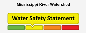
A Water Safety Statement is to provide notice of high flows, unsafe banks, melting ice or other factors that could be dangerous for recreational users such as anglers, canoeists, hikers, children, pets, etc. Flooding is not expected.
This Water Safety Statement is an update to the Flood Watch for the Mississippi River Watershed issued on April 28, 2026.
Weather Forecast: Seasonal temperatures are expected over the next two weeks, with daytime highs in the 10–15°C range. Light precipitation is forecast over the next seven days, with cumulative totals up to 30 mm. No significant weather systems are currently anticipated.
Watershed Conditions: Water levels and flows are gradually returning to seasonal norms. Some lakes remain in water safety conditions, and spring rainfall events may temporarily elevate additional lakes into similar conditions.
At this time, water levels and flows are not expected to increase significantly, and system operations are transitioning toward maintaining stable conditions for summer recreation and seasonal water use.
Risks: Rivers and streams may experience higher water levels, fast flowing water and slippery or unstable banks.
Actions: Residents are reminded to exercise extreme caution near all water bodies due to high flows and slippery conditions. Parents are encouraged to remind children about these dangers and provide appropriate supervision.
Residents in flood prone areas are advised to maintain close watch on water levels and flows and take the necessary precautions to protect their property by:
- Ensuring sump pumps are clear, in good working condition and have a backwater valve.
- Having a portable generator and backup pump available.
- Ensuring downspouts are clear and the outlet is at least 3 meters from any structure.
- Removing or securing items that might float away if flows increase.
- Keeping emergency phone numbers handy.
- Familiarizing yourself with your municipality’s emergency preparedness plan.
Duration: This message is in effect until May 12, 2026 at 5:00PM or until an update has been issued.
For More Information: Daily water levels and flows are available on the MVCA website at www.mvc.on.ca/water-levels. For more information, contact:
MVCA Water Management
613-253-0006 ext. 248
This email address is being protected from spambots. You need JavaScript enabled to view it.
NEWSROOMS PLEASE NOTE:
A Watershed Conditions Statement is NOT a flood warning. Its purpose is to raise public awareness about a change or potential change in watershed conditions.
See below for watershed conditions terminology:
Watershed Conditions Statement: General notice of weather conditions that could pose a risk to personal safety or which have the potential to lead to flooding. There are two variations of these:
- Water Safety Statement: High flows, unsafe banks, melting ice or other factors could be dangerous for recreational users such as anglers, canoeists, hikers, children, pets, etc. Flooding is not expected.
- Flood Outlook Statement: Early notice of the potential for flooding based on weather forecasts calling for heavy rain, snowmelt, high wind or other conditions that could lead to high runoff, cause ice jams, lakeshore flooding or erosion.
Flood Watch: Flooding is possible in specific watercourses or municipalities. Municipalities, emergency services and individual landowners in flood-prone areas should prepare.
Flood Warning: Flooding is imminent or already occurring in specific watercourses or municipalities. Municipalities and individuals should act to deal with flood conditions. This may include road closures and evacuations.
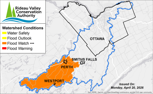
Rideau Valley Conservation Authority
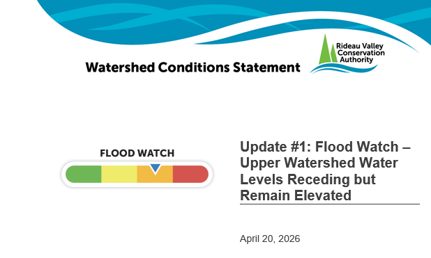
(WCS – R05/2026)
A Flood Watch has been extended for the Tay Valley and Rideau Lakes regions in the Upper Rideau Watershed. Water levels across the upper watershed lakes remain elevated but are now stable or gradually declining following peak conditions. Flood risk has decreased, though flooding impacts may persist in low-lying areas until water levels recede further.
Residents are encouraged to continue monitoring local conditions and maintain appropriate precautions until water levels return to more typical seasonal levels.
More Details:
Weather Forecast: Environment Canada is forecasting daytime highs of approximately 4 to 6°C through April 21, increasing to 14 to 19°C across the region through late April. Minimal rainfall is expected over the short to mid-term range.
Environmental Conditions: Water levels and flows across the Rideau Valley watershed remain elevated following the recent spring freshet. Peak water levels have occurred in the upper watershed lakes, and conditions are now generally in recession.
Snowpack across the watershed has been depleted, and runoff contributions have decreased significantly. While inflows have reduced, water levels within the reservoir system remain high due to the cumulative effects of earlier snowmelt and rainfall, as well as reduced available storage capacity.
Risks: Flood risk has decreased from peak conditions, with the following risk factors remaining:
- Elevated water levels may continue to impact low-lying areas and locations historically prone to flooding
- Localized nuisance flooding may persist while water levels gradually decline
Location-Specific Considerations:
Tay River Subwatershed – Bobs Lake & Christie Lake
Water levels remain elevated within the upper Tay River system, including Bobs Lake and Christie Lake, but are generally trending downward. Flooding impacts in low-lying and historically flood-prone areas may persist in the near term. Residents should continue to monitor conditions and maintain protective measures as water levels recede. Parks Canada continues to actively manage conditions within the system.
Upper Rideau Subwatershed – Reservoir Lakes
Water levels across Wolfe Lake, Upper Rideau Lake, and Big Rideau Lake remain elevated but are stabilizing or gradually declining. Localized nuisance flooding may persist while water levels gradually recede.
Action & Safety Recommendations: Residents in flood-prone areas are advised to remain vigilant and continue to take appropriate precautions, including:
- Ensuring sump pumps are clear, in good working condition, and have a backwater valve;
- Keeping a portable backup generator and pump easily accessible;
- Ensuring downspouts are clear and directing water at least 3m away from the dwelling;
- Securing items that might float away;
- Removing valuable items from basements or lower areas susceptible to flooding;
- Keeping emergency contact numbers readily available;
- Reviewing municipal Emergency Preparedness Plans.
Duration: This Flood Watch remains in effect until May 6, 2026 at 11:59 pm or until an update has been issued.
RVCA continues to monitor watershed conditions and will provide updates as required.
For more information, visit www.rvca.ca or contact:
Justin Robert, Flood Duty Officer
1-800-267-3504 ext. 1194
This email address is being protected from spambots. You need JavaScript enabled to view it.
Media Contact:
Emma Jackson, Communications Specialist
1-800-267-3504 ext. 1184
This email address is being protected from spambots. You need JavaScript enabled to view it.
Newsrooms please note: A Watershed Conditions Statement is NOT a flood warning. Its purpose is to raise public awareness about a change or potential change in watershed conditions.
RVCA Watershed Conditions Statements:
- Water Safety – High flows, unstable banks, melting ice or other factors that could be dangerous for recreational users such as anglers, canoeists, hikers, children, pets, etc. Flooding is not expected.
- Flood Outlook – Early notice of the potential for flooding based on weather forecasts, calling for heavy rain, snow melt, high winds or other conditions that could lead to high runoff, cause ice jams and/or lakeshore flooding or erosion.
- Flood Watch – Flooding is possible in specific watercourses or municipalities. Municipalities, emergency services and individuals in flood prone areas should prepare.
- Flood Warning – Flooding is imminent or already occurring in specific watercourses or municipalities.
